Examine the latest developments in atmospheric science and you will find a surprising intersection between agricultural technology and astrophysics. In a recent space weather news update, the University of Surrey announced a rapid-response research project to analyze the November 2025 radiation storm. Funded by the Natural Environment Research Council (NERC), this initiative utilizes a global network of soil moisture sensors to map the localized impacts of space weather on the Earth’s surface. This approach offers an unprecedented level of detail regarding how radiation storms affect different geographical regions. Explore our related articles for further reading on how existing technologies are being repurposed for scientific discovery.
Understanding the November 2025 Space Weather Radiation Storm
Space weather encompasses a variety of environmental conditions in the Earth’s upper atmosphere and near-space environment. Among the most significant events are Ground Level Enhancements (GLEs). A GLE occurs when high-energy particles emitted by the Sun—typically during a major solar flare or coronal mass ejection—strike the Earth’s atmosphere with enough force to create a cascade of secondary particles that reach the ground.
The radiation storm in November 2025 was a stark reminder of the vulnerabilities inherent in modern technology. During this event, nearly 6,000 Airbus A320 aircraft were grounded due to concerns over radiation exposure and potential system failures. This incident highlighted a critical gap in our observational capabilities. While scientists knew a radiation storm was occurring, existing monitoring networks were too sparse to determine the exact severity of the radiation at specific locations.
Historically, GLEs have been infrequent, with the largest prior to November 2025 occurring nearly 20 years ago. However, as society becomes increasingly reliant on satellite communications, global positioning systems, and high-altitude aviation, the potential disruption caused by a severe radiation storm grows exponentially. The UK National Risk Register currently places space weather second only to a pandemic in terms of national hazard priority, underscoring the urgent need for improved monitoring and forecasting capabilities.
Repurposing Agricultural Technology for Space Weather News
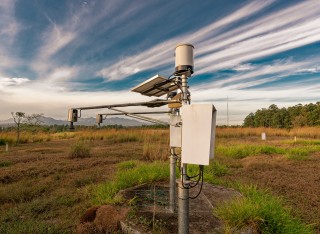
At the center of this research is an ingenious repurposing of existing infrastructure. Soil moisture sensors are standard tools in agriculture, environmental monitoring, and climate science. They are deployed globally to measure the water content in soil, which is vital for crop management and weather forecasting. However, the physical mechanism these sensors use to measure moisture makes them unexpectedly valuable for tracking a radiation storm.
How Soil Moisture Sensors Detect Cosmic Radiation
These sensors do not measure water directly; instead, they measure neutron radiation near the Earth’s surface. Hydrogen atoms in water are highly effective at moderating, or slowing down, fast-moving neutrons. By measuring the concentration of neutrons above the soil, scientists can accurately calculate the amount of moisture present in the ground.
During a space weather event, high-energy particles from the Sun collide with atoms in the upper atmosphere. These collisions generate a shower of secondary neutrons that travel toward the ground. When a radiation storm hits, the neutron count measured by soil moisture sensors spikes dramatically. Because these sensors are calibrated to detect minute changes in neutron levels, they inadvertently capture the precise signature of solar radiation storms with high fidelity. By aggregating data from these dense sensor networks across the UK, US, Germany, and Australia, researchers can reconstruct the event in extraordinary detail without needing to deploy specialized, expensive radiation detectors.
The Uneven Impact of Space Weather Across the UK
Conventional approaches to space weather often treat it as a uniform, global phenomenon. However, data from the November 2025 event proves that the impact of a radiation storm varies drastically depending on geographic location, geomagnetic latitude, and local atmospheric conditions.
Consider the contrasting data points from the UK during the November storm. In Lerwick, Scotland, which sits at a higher geomagnetic latitude, ionizing radiation in the atmosphere doubled in just 10 minutes. Conversely, in Guildford, England, radiation levels increased by only 10 percent over the span of an hour. Traditional space weather monitoring systems, which are few and far between, cannot capture the granular variations that occur between these two points. They provide broad averages rather than localized realities.
The University of Surrey project aims to fill these observational gaps. By analyzing the data from thousands of distributed soil moisture sensors, researchers can map how the radiation storm’s intensity ebbed and flowed across different terrains and latitudes. This localized mapping is crucial for industries that operate regionally, such as regional airlines, power grid operators, and emergency management services. Schedule a free consultation to learn more about how localized environmental data can impact operational planning.
Protecting Critical Infrastructure from a Radiation Storm
Understanding the precise geographic impact of a radiation storm is not merely an academic exercise; it is a fundamental requirement for protecting critical infrastructure. When high-energy particles penetrate the atmosphere, they pose distinct threats to various technological systems.
Aviation and Satellite Vulnerabilities
The aviation sector is acutely vulnerable to space weather. At cruising altitudes, aircraft are above much of the protective layer of the Earth’s atmosphere, exposing passengers and crew to higher levels of cosmic radiation. Furthermore, solar particles can cause single-event upsets in aircraft avionics—essentially flipping bits in computer memory, which can lead to system resets or erroneous data processing. The grounding of the Airbus A320 fleet demonstrates that when the severity of a radiation storm cannot be accurately quantified, the only safe operational choice is to cancel flights, resulting in massive economic losses and logistical disruptions.
Satellites face similar, though more prolonged, threats. A radiation storm can degrade solar panels, damage sensitive electronic components, and cause premature satellite failure. By understanding exactly how hard the Earth’s atmosphere was hit during a specific event, satellite operators can better estimate the radiation dose their hardware absorbed and adjust operational lifespans accordingly.
The Future of UK Space Weather Monitoring
Backed by £100,000 in NERC funding, the nine-month project running from April 2026 is being led by Dr. Fraser Baird and Professor Keith Ryden at the Surrey Space Centre. Their work promises to deliver the most detailed report of a ground-level space weather radiation event in recent history.
Dr. Baird emphasizes the cost-effectiveness of this approach: “These soil sensors are already deployed around the world for environmental monitoring. If we can use them to detect space weather too, it opens up a completely new, cost-effective way of observing these events.” This sentiment is echoed by Professor Ryden, who notes that repurposing existing infrastructure addresses significant risks while providing long-term benefits for space science. Have questions about this space weather news? Write to us! to discuss the implications for environmental monitoring.
The success of this methodology could fundamentally change how governments and agencies approach space weather monitoring. Instead of relying solely on a limited number of highly specialized detectors, meteorological agencies could integrate soil moisture sensor data into their forecasting models in real-time. This dual-use approach maximizes the value of agricultural investments while simultaneously building a robust, high-resolution shield against space weather hazards.
Conclusion and Next Steps
Repurposing soil moisture sensors to track a space weather radiation storm represents a significant leap forward in atmospheric science. By leveraging existing global networks, the University of Surrey is developing a method to map the highly localized impacts of GLEs, providing the granular data needed to protect aviation, satellites, and critical infrastructure. As the UK continues to prioritize space weather resilience, this research demonstrates that innovative solutions often lie in looking at existing technologies through a new lens.
For students and professionals interested in the intersection of environmental science, space engineering, and data analysis, projects like this highlight the dynamic career opportunities available in the space sector. Submit your application today to explore academic programs that prepare you for the challenges of space weather monitoring. Share your experiences in the comments below regarding how unexpected technological overlaps can solve complex scientific problems.