
Trace Ancient Geography: How Loughborough University Explores Mapping The Odyssey
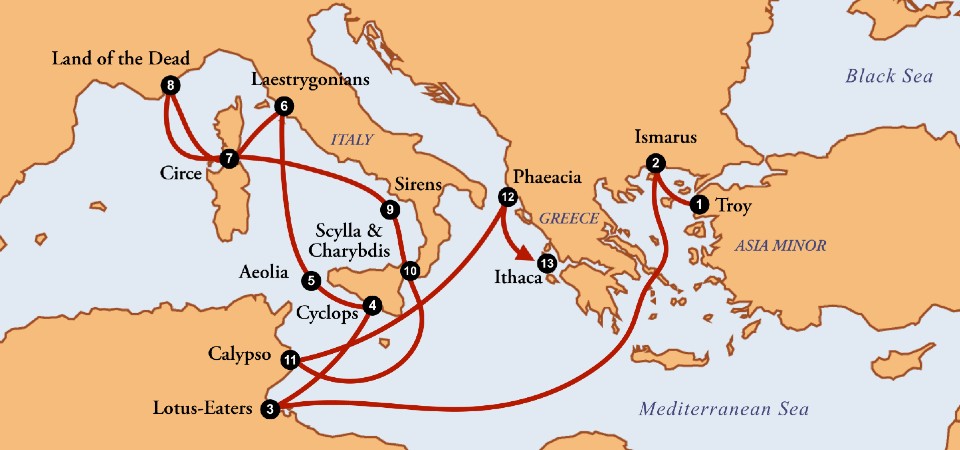
Homer’s epic poem, The Odyssey, has captivated readers for millennia with its tale of monsters, divine interventions, and a king’s perilous ten-year journey home to Ithaca. Yet, beyond its literary brilliance, the text presents a distinct geographic puzzle. For centuries, scholars, historians, and geographers have debated the physical reality of the locations described in the poem. Can we actually plot Odysseus’s travels on a modern map? Recent academic discourse, including insights from Loughborough University, UK, suggests that examining this intersection of literature and spatial data offers profound insights into how ancient civilizations understood their world.
Explore our related articles for further reading on classical studies and historical research methodologies.
Examine the Intersection of Literature and Ancient Geography
Ancient geography was not merely the study of physical landscapes; it was a complex blend of empirical observation, mythology, and narrative storytelling. When we look at texts like The Odyssey through the lens of mapping history, we are not simply trying to pin down a dot on a modern satellite map. Instead, we are attempting to reconstruct the spatial consciousness of the ancient Mediterranean world.
The geographic elements within Homer’s epic serve a functional purpose. They ground the supernatural elements of the story in a recognizable reality. The mention of real-world locations—such as the island of Sicily, the Strait of Messina, and the coast of Ithaca—provides a spatial framework that ancient audiences could visualize. This practice of embedding narratives within geographic realities is a cornerstone of ancient geography, serving as a primitive form of cartography where oral traditions and poetic verse functioned as mental maps for seafarers and listeners alike.
Evaluate the Historical Debate Over The Odyssey’s Real-World Locations
The academic debate regarding the mappability of The Odyssey is sharply divided. For centuries, two primary schools of thought have dominated classical studies.
The Mythological Perspective and Eratosthenes
On one side are scholars who argue that the epic is purely a work of art and mythology, entirely detached from physical geography. The most prominent historical voice in this camp is Eratosthenes, the ancient Greek polymath who famously calculated the circumference of the Earth with remarkable accuracy. Eratosthenes firmly dismissed the idea that The Odyssey held any geographic value. He famously mocked those who tried to map the poem, stating that they would only find the locations “when you find the cobbler who sewed up the bag of the winds.”
From this viewpoint, attempting to map the wanderings of Odysseus is a futile exercise in chasing fairy tales. The islands of the Cyclopes, the lair of Scylla and Charybdis, and the enchanted gardens of Circe are viewed as symbolic landscapes representing human fears, temptations, and the unknown perils of the open sea, rather than coordinates waiting to be discovered.
The Geographical Perspective and Polybius
p>Conversely, other historians have argued that The Odyssey is a dramatized account of real voyages, rooted in genuine geographic knowledge. The ancient Greek historian Polybius, writing roughly six centuries after Homer, took a pragmatic approach to the text. He argued that the poem described a real journey that had simply been embellished with mythological elements over time.
Polybius looked for tangible evidence within the text to support his claims. For instance, he pointed to the detailed descriptions of fishing practices near the monster Scylla. He noted that these specific techniques matched the practices of fishermen in the islands near Sicily. By cross-referencing the textual evidence with known regional customs, Polybius concluded that Scylla must logically be located off the Sicilian coast. This methodology represents an early form of spatial analysis, using cultural and geographic data points to validate literary sources.
Apply Modern Cartography Research to Classical Texts
Today, the discipline of mapping history has evolved significantly, incorporating tools and perspectives from modern cartography, digital humanities, and cognitive psychology. Researchers no longer rely solely on textual analysis; they examine how space and movement influence narrative structure and character development.
Professor Pragya Agarwal, a researcher at Loughborough University, UK, has contributed significantly to this modern approach. With over two decades of research focusing on the history of cartography and mental mapping, Professor Agarwal approaches The Odyssey not just as a puzzle to be solved, but as a spatial experience to be analyzed.
Schedule a free consultation to learn more about our research programs and spatial humanities initiatives.
The argument put forward is that the geographic elements of the story are precisely what grounds the epic. Odysseus’s desire to find a way home is the driving force of the narrative, and his psychological state shifts in direct correlation to the spaces he occupies. The disorientation of the open sea, the confinement of Calypso’s island, and the familiar ruggedness of Ithaca all act as geographic catalysts for his character arc. By mapping these transitions, researchers can better understand how ancient authors used geography as a narrative device.
Understand the Role of Mental Mapping in Classical Narratives
A crucial concept in modern cartography research is “mental mapping”—the cognitive process by which individuals internalize, store, and recall information about their physical environment. Before the advent of standardized paper maps and GPS, ancient peoples relied heavily on mental maps constructed through oral traditions, personal experience, and storytelling.
The Odyssey functions as an elaborate mental map for its audience. As listeners heard the poem, they were actively constructing a spatial model of the Mediterranean in their minds. The sequence of the islands, the direction of the winds, and the duration of the sails all contributed to a shared geographic understanding. This process of mapping history mentally allowed ancient Greeks to conceptualize their expanding world, defining the boundaries of the known and the terrifying expanse of the unknown.
Modern researchers study these ancient mental maps to understand how spatial awareness influenced cultural development. The way an ancient society maps its myths tells us what they feared, what they valued, and how they navigated both their physical seas and their societal challenges.
Share your experiences in the comments below regarding how geography has influenced your understanding of classical literature.
Connect Historical Cartography with Contemporary Academic Research
The question of whether we can map The Odyssey does not exist in a vacuum; it is part of a broader academic pursuit to understand human spatial cognition across different eras. Institutions like Loughborough University, UK, demonstrate a strong commitment to this type of interdisciplinary research. With over 90% of its research rated as ‘world-leading’ or ‘internationally excellent’ in the recent Research Excellence Framework (REF), the university fosters an environment where historical texts are analyzed through modern, innovative lenses.
Bridging the gap between ancient geography and contemporary spatial analysis allows academics to draw parallels between past and present. Just as ancient sailors used stories and stars to navigate the Mediterranean, modern societies use data and digital maps to navigate complex global networks. Studying the foundational texts of mapping history provides valuable context for how humans have always sought to make sense of their place in the world.
Summary and Next Steps for Aspiring Researchers
While we may never definitively pinpoint the exact coordinates of every island Odysseus visited, the effort to map The Odyssey yields significant academic rewards. It challenges us to look beyond the surface of ancient texts and engage with the spatial logic that underpins them. Whether viewing the poem as pure myth through the lens of Eratosthenes, or as a distorted account of real geography through the eyes of Polybius, the exercise enriches our understanding of the ancient world.
The integration of cartography, history, and literature represents a dynamic field of study that continues to evolve. For students and enthusiasts eager to explore how spatial data shapes human narrative, engaging with this type of research is an excellent starting point.
Have questions? Write to us! If you are passionate about history, geography, and the intersection of the two, consider how you can contribute to this ongoing academic conversation.
Submit your application today to explore academic programs that bridge the humanities and spatial sciences.